
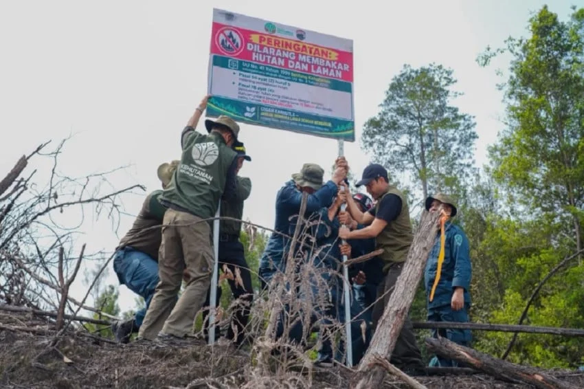
The Ministry of Forestry has officially initiated a comprehensive security campaign across multiple forest zones in Central Kalimantan that were recently devastated by severe forest and land fires, locally known as karhutla. Official operations on the ground now feature the prominent placement of warning signs and legal notices prohibiting any unauthorized activities within these vulnerable perimeters. This strategic measure has been deployed to reinforce legal oversight, secure state forest assets, and decisively prevent illegal encroachment, unauthorized land clearing, and illicit logging within fragile ecosystems that are still undergoing recovery assessments.
The newly erected signage specifically targets areas managed under Business Permits for Forest Utilization, commonly abbreviated as PBPH. These particular corporate concessions faced strict punitive measures and administrative sanctions from the Ministry of Forestry following comprehensive environmental evaluations that linked the devastating blazes to management negligence or regulatory non-compliance. The imposed penalties encompass the formal suspension of operational permits alongside mandatory legal obligations compelling the concession holders to fund and execute full forest ecosystem restoration plans. By clearly marking these zones with prohibitive signage, regulatory authorities aim to establish absolute transparency regarding the restricted legal status of the land while deterring opportunistic actors from exploiting the administrative vacuum created by corporate suspensions.
Background Context and Environmental Vulnerability in Central Kalimantan
Central Kalimantan has historically served as one of Indonesia’s primary focal points for environmental policy enforcement regarding land and forest fires. The province’s vast expanse of tropical rainforests and carbon-rich peatland ecosystems makes it exceptionally susceptible to rapid fire propagation during extended dry seasons, often exacerbated by human-induced land clearing practices. When fires sweep through these regions, they not only destroy valuable timber and endanger local biodiversity—including critically endangered species like the Bornean orangutan—but they also destabilize the soil structure and clear vegetative cover, leaving the landscape wide open to environmental degradation.
In the aftermath of major fire events, deforested and scorched lands routinely face elevated threats of illegal occupation. Local and external actors frequently attempt to seize control of recovering plots for unauthorized agricultural expansion, illegal mining, or illicit timber harvesting. Because the administrative oversight of these lands often enters a transitional gray zone when a corporate permit is frozen or revoked, illegal operators exploit the temporary lack of active commercial presence. The Ministry of Forestry’s current intervention directly addresses this vulnerability, ensuring that suspended concessions do not transform into lawless zones free from state control.
Chronology of Enforcement and Regulatory Crackdowns
The deployment of warning signs in Central Kalimantan is the latest milestone in an escalating series of regulatory enforcement actions spearheaded by the Ministry of Forestry. The timeline of this intensified crackdown traces back to comprehensive satellite monitoring and field inspections conducted during the peak of the dry season, which identified widespread thermal anomalies and massive smoke plumes originating from various corporate concessions across Kalimantan and Sumatra.
Following preliminary investigations, forestry officials gathered empirical evidence pointing toward systemic failures in fire prevention and suppression infrastructure within specific concession boundaries. Consequently, the Ministry initiated swift administrative and judicial responses:

- Initial Investigation and Satellite Mapping: Environmental monitoring units utilized advanced remote-sensing technology to pinpoint exact coordinates of severe burning within PBPH concession areas in Central and West Kalimantan.
- Sanction Imposition: Based on preliminary findings, the Ministry of Forestry issued formal administrative sanctions, which included the immediate freezing of operating licenses for non-compliant corporations and the issuance of strict mandates for ecosystem restoration.
- Criminal Proceedings: In parallel with administrative penalties, forestry law enforcement agencies escalated cases toward criminal prosecution. Notably, the Ministry recently designated multiple major corporations as formal suspects in ongoing investigations regarding alleged deliberate or negligent forest burning.
- On-the-Ground Security Enhancement: As a vital follow-up to administrative freezes, the Ministry deployed field teams to physically secure the premises, culminating in the recent installation of warning banners and legal prohibition plaques across strategic points in Central Kalimantan.
Official Responses and Leadership Strategy
The intensification of field-level security underscores a strategic pivot in how Indonesia manages forestry law enforcement amid logistical constraints. Addressing the media regarding ongoing operations, Minister of Forestry Raja Juli Antoni emphasized that institutional limitations—such as a shortage of active Forest Police personnel, known locally as Polhut—must never be used as a justification for lax environmental protection or reduced oversight.
Minister Antoni articulated a mandate for smarter, highly tactical resource allocation. Rather than attempting to maintain a continuous physical presence across every square kilometer of forest land, enforcement units are directed to leverage data-driven intelligence. By cross-referencing satellite hotspot data, historical burn scars, and concession ownership registries, the Ministry can accurately identify regions exhibiting the highest levels of ecological vulnerability and criminal risk. This targeted approach allows limited personnel to maximize their deterrent impact where it is needed most.
Furthermore, the Ministry has stressed that inter-agency coordination remains a cornerstone of this campaign. Collaboration with regional law enforcement agencies, local government bodies, and civil society organizations ensures that once a zone is designated as restricted, any violation reported via local surveillance or satellite tracking is met with swift punitive action.
Broader Impacts and Long-Term Implications
The installation of prohibitive signage and the rigorous enforcement of administrative suspensions carry profound implications for Indonesia’s forestry sector and its broader international climate commitments. For decades, the perennial recurrence of karhutla has generated severe domestic economic disruptions, public health crises due to toxic haze, and intense diplomatic scrutiny from neighboring countries affected by transboundary smoke pollution.
By holding corporate permit holders directly accountable through permit freezes, mandatory restoration orders, and criminal indictments, the government is signaling a zero-tolerance policy toward environmental negligence. The transformation of fire-damaged concessions into legally protected, restricted-access zones ensures that companies cannot simply abandon burned land to evade liability or profit from subsequent illegal land uses.
Moreover, these measures reinforce the credibility of Indonesia’s national carbon accounting and forestry governance frameworks. As international carbon markets and multilateral climate finance mechanisms increasingly demand verifiable proof of forest protection and effective peatland restoration, strict monitoring of deforested areas is paramount. Preventing secondary degradation in post-fire zones allows natural secondary succession or active reforestation initiatives to proceed unimpeded, gradually restoring the ecological integrity and carbon sequestration capacity of Central Kalimantan’s vital landscapes.
Ultimately, the active marking and monitoring of former fire zones in Central Kalimantan represent a critical bridge between policy formulation on paper and practical enforcement on the ground. As the Ministry of Forestry continues to refine its intelligence-led surveillance models, these localized security measures serve as an uncompromising reminder that state authority and environmental law extend into every corner of the nation’s forest estate, regardless of corporate status or operational suspension.