
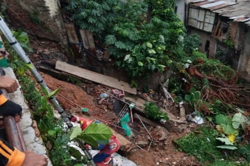
Jakarta faces severe weather challenges as urban density, changing climate patterns, and aging infrastructure converge to heighten risks for vulnerable neighborhoods. This reality was underscored on Tuesday, November 10, 2026, when a destructive landslide struck a densely populated residential zone along Jalan Kemang Selatan X, located in the Bangka sub-district of Mampang Prapatan, South Jakarta. Triggered by a combination of torrential rainfall and sudden subterranean ground movement, the disaster damaged multiple properties and disrupted the lives of dozens of residents.
The incident highlights the growing vulnerability of Jakarta’s urban waterways and residential zones during extreme weather events. As municipal authorities grapple with the aftermath, the event has reignited urgent conversations regarding slope stabilization, drainage capacity, and climate resilience in the Indonesian capital.
Main Facts of the Disaster
The landslide occurred at approximately 14:10 Western Indonesia Time (WIB) following an intense downpour that lashed South Jakarta throughout the early afternoon. According to initial damage assessments released by the Jakarta Regional Disaster Management Agency (BPBD DKI Jakarta), the disaster directly impacted five residential structures alongside a perimeter wall and adjacent land plots owned by local residents.
While initial emergency evaluations generated conflicting reports regarding displacement figures—with preliminary field logs noting eight families seeking temporary shelter before official stabilization checks concluded that immediate long-term displacement was successfully avoided—the structural toll on the affected properties remains severe. The shifting earth compromised foundations, fractured boundary walls, and left several homes in immediate structural jeopardy.
Marulitua Sijabat, Head of Operations for BPBD DKI Jakarta, confirmed that emergency response teams were deployed immediately to secure the perimeter and mitigate the risk of secondary collapses. Despite the dramatic nature of the collapse, disaster mitigation officials confirmed that no fatalities or severe injuries were recorded among residents or passersby. However, the calculation of total material losses remains ongoing as engineers and forensic surveyors evaluate the full extent of the subterranean damage.
Chronology and Sequence of Events
Understanding the rapid escalation of the Jalan Kemang Selatan X landslide requires examining the precise sequence of events leading up to the collapse. Meteorologists and eyewitness accounts point to a convergence of compounding environmental factors that transformed a routine afternoon rainstorm into a geological emergency.
The morning of November 10 began with overcast skies and intermittent light showers across South Jakarta, consistent with forecasts for the regional wet season. By early afternoon, however, localized convective clouds intensified rapidly, unleashing a torrential downpour characterized by high precipitation rates per hour.
At approximately 13:50 WIB, residents living along the embankment of Jalan Kemang Selatan X reported hearing unusual, deep-seated rumbling noises emanating from beneath the soil. These acoustic warnings were quickly followed by noticeable ground vibrations that shook foundations and rattled windows. Within twenty minutes, as the rainfall peaked, the structural integrity of the soil interface collapsed entirely.
Eyewitnesses described a sudden, shearing motion as retaining walls buckled and sections of earth slid downward toward lower-lying drainage channels. The rapid displacement of soil dragged boundary fences down with it and pushed precariously close to the structural pillars of neighboring homes.
By 14:15 WIB, local neighborhood coordinators had alerted emergency services. Personnel from BPBD DKI Jakarta, the local fire and rescue department, police, and sub-district apparatus arrived on the scene within minutes. First responders established a safety perimeter, cut off electrical supplies to the most severely damaged homes to prevent fires, and assisted residents in retrieving essential belongings while evaluating the immediate risk of further subsidence.
Supporting Data and Contextualizing Urban Landslides in Jakarta
To fully comprehend the gravity of the Kemang Selatan landslide, it is essential to examine Jakarta’s broader hydrological and geological landscape. The Indonesian capital is situated on a low-lying alluvial plain crossed by numerous rivers and drainage basins, making it inherently susceptible to flooding and soil destabilization.
South Jakarta, while generally possessing higher topography than the northern coastal districts, is characterized by undulating terrain, numerous riverbanks, and former marshlands that have been heavily urbanized over the past several decades. Rapid urban development has seen natural catchment areas, permeable soils, and dense vegetation replaced by concrete, asphalt, and multi-story buildings. This concrete canopy significantly reduces rainwater infiltration rates, forcing massive volumes of water into surface drainage systems and increasing runoff velocity.
Furthermore, soil mechanics in riverine and low-lying urban sectors like Bangka often involve layers of soft clay, silt, and loose sedimentary deposits. When subjected to prolonged or high-intensity rainfall, these soils absorb moisture rapidly, increasing pore water pressure. As water pressure builds within the subterranean strata, internal friction between soil particles decreases, ultimately triggering slope failures and landslides.
This incident in Kemang is not an isolated occurrence within the greater metropolitan area. Similar ground movement phenomena have been documented in adjacent regions, such as a notable geological shift in Babakan Madang, Bogor regency, which damaged numerous homes earlier in the cycle. These recurring events illustrate a regional vulnerability where intense tropical precipitation interacts with anthropogenic landscape alterations to destabilize residential zones.
Official Responses and Institutional Coordination
In the immediate aftermath of the disaster, municipal agencies moved swiftly to coordinate relief efforts and stabilize the affected corridor. BPBD DKI Jakarta spearheaded the cross-agency response, mobilizing personnel from the Public Works (Dinas Sumber Daya Air and Dinas Bina Marga) offices to inspect drainage networks and slope stability.
Marulitua Sijabat emphasized that municipal authorities are prioritizing thorough site investigations to determine the exact mechanical triggers of the ground shift. "The primary objects impacted include boundary walls and land plots, alongside five surrounding residential structures," Sijabat stated during an official briefing. "The root cause has been identified as a combination of heavy rainfall and subsequent subterranean ground movement."
Local authorities also addressed immediate humanitarian concerns. While initial field reports suggested that up to eight households might require evacuation due to proximity to the unstable zone, subsequent engineering assessments allowed several residents to remain in secure portions of their homes or stay with nearby relatives, reducing the need for formal public evacuation camps. Social service agencies (Dinas Sosial) were placed on standby to provide logistical support, psychological first aid, and basic sustenance should secondary evacuations become necessary.
Engineering teams have since deployed geotechnical monitoring tools to measure ongoing ground movement. Because landslides of this nature can feature delayed secondary collapses—particularly if residual water continues to drain through the soil layers—authorities have restricted public access to the immediate perimeter of the collapsed slope.
Broader Impact and Implications for Urban Infrastructure
The landslide at Jalan Kemang Selatan X serves as a stark reminder of the complex infrastructure challenges facing Jakarta as it navigates rapid urban expansion amidst intensifying climate volatility. Several key implications emerge from this event for urban planners, policymakers, and residents alike:
-
Stricter Zoning and Building Codes Along Waterways
The encroachment of residential and commercial structures onto riverbanks and steep embankment edges remains a critical vulnerability in Jakarta. Urban planners have long warned that historical zoning enforcement along drainage corridors has been inconsistent. Events like the Kemang landslide demonstrate the urgent need for stringent enforcement of buffer zones along waterways, ensuring that heavy construction and permanent residential dwellings are kept at a safe distance from unstable slopes. -
Infrastructure Maintenance and Drainage Modernization
Subterranean ground movement is frequently exacerbated by compromised drainage infrastructure. Leaking underground pipes, overflowing septic tanks, and blocked stormwater channels can saturate local soil layers from within, accelerating the destabilization process even independently of surface rainfall. Municipal authorities must accelerate the audit and modernization of underground utility networks in high-risk zones across South Jakarta. -
Climate Adaptation and Early Warning Systems
With climate change driving more frequent and intense meteorological anomalies across Southeast Asia, urban disaster management frameworks must evolve. Traditional reactive emergency response is no longer sufficient; cities require proactive, technology-driven early warning systems. Integrating real-time soil moisture sensors, rainfall telemetry, and inclinometers in known landslide-prone neighborhoods can provide crucial lead time for evacuation, minimizing both human and material losses. -
Property Insurance and Financial Risk Mitigation
The financial toll of urban geohazards often falls entirely upon individual homeowners, many of whom lack comprehensive property insurance coverage for natural disasters like landslides and subsidence. The incident at Kemang highlights a broader systemic need for accessible disaster risk insurance products and clearer legal frameworks regarding liability and municipal support when public infrastructure failures contribute to private property damage.
Looking Ahead
As recovery efforts at Jalan Kemang Selatan X transition from emergency containment to long-term reconstruction, the local government faces the complex task of engineering permanent slope stabilization solutions. Retaining wall reconstruction, soil nailing, and improved surface drainage diversion are expected to be implemented in the coming weeks to secure the embankment before subsequent rounds of heavy seasonal rainfall arrive.
For the residents of Bangka and the wider South Jakarta community, the event has left an indelible mark, highlighting the fragile equilibrium between urban living and the natural environment. As Jakarta continues its transition toward becoming a global metropolitan center, addressing these foundational vulnerabilities through rigorous engineering, proactive governance, and sustainable urban planning will remain paramount in safeguarding its population from the unpredictable forces of nature.
